Wu Su, He Li and co-authors: physics-guided multi-source data fusion for reconstructing the 3D current fields of oceanic mesoscale eddies, accepted by JASA
The paper “Physics-guided Statistical Data Fusion for Reconstructing 3D Current Fields of Oceanic Eddies” by Wu Su, He Li and co-authors has been accepted for publication by the Journal of the American Statistical Association (JASA). The work proposes a physics-guided multi-source data fusion framework that reconstructs the three-dimensional current field of a mesoscale eddy in near real time, and applies it to real-time decision-making during a sea-going observation campaign.
Mesoscale eddies are the ocean’s “hidden engines” (Figure 1): their three-dimensional current structure governs the vertical transport of heat and material, ecosystem dynamics, and air–sea interaction. Yet the eddy interior has long been extraordinarily difficult to observe in situ. Currents there are strong and fast-varying, with surface speeds in the core exceeding 1 m/s against a glider cruising speed of only about 0.3 m/s, so underwater platforms struggle to hold a controlled course; and existing velocity observations are almost entirely confined to the sea surface.
Mounting a coordinated in situ survey, however, requires knowing the eddy’s interior current field in advance: where to sample, how to lay out the glider paths, and how to steer in real time all depend on it. No existing data source suffices on its own. Satellite altimetry has broad coverage, but its surface current retrievals carry systematic biases and say nothing about the interior. Drifting buoys are accurate, but few, covering only about one-tenth of the study area on a given day. And reanalysis products such as GLORYS, though they deliver a complete three-dimensional field, still differ appreciably from the real ocean.
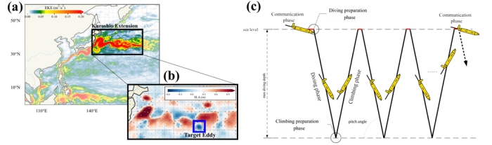
Figure 1. Observational setting: (a) mean eddy kinetic energy in the northwestern Pacific; (b) sea level anomaly and current field of the target eddy; (c) glider dive-and-climb cycle.
For the surface current field, the paper builds a high-dimensional linear mixed model (HD-LMM) that explicitly parameterizes the systematic bias of the satellite-derived field as a function of longitude, latitude and surface wind, then corrects it using the accurate but sparse drifting-buoy observations, with a multi-directional bandable covariance capturing the spatial dependence of the field. Regressing the AVISO-minus-buoy velocity difference on the bias-model covariates yields an average R² of about 80%, confirming that the model captures the spatially varying component of the satellite retrieval error (Figure 2).
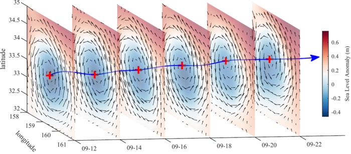
Figure 2. Evolution of the reconstructed surface current field: color denotes sea level anomaly, arrows denote surface velocity, and crosses mark the eddy center.
On this basis the paper recovers the interior field using physics. At mid-latitudes the Coriolis effect dominates, and at small Rossby number geostrophic balance follows from the Navier–Stokes equations, supplying a physical constraint on the vertical structure. Guided by this, a convolutional neural network is trained on GLORYS reanalysis data to learn the mapping from the surface current field and sea surface temperature to the interior three-dimensional field, which is then applied to the HD-LMM-corrected surface field.
Validation uses five-fold cross-validation against drifting buoys and independent shipboard ADCP transects. The total velocity error of the proposed method is only 22% of that of GLORYS, 32% of AVISO and 63% of Kriging interpolation, and its accuracy across depths also exceeds that of climatology, GLORYS and the physics-based isQG inversion (Figure 3).
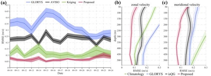
Figure 3. Reconstruction accuracy: (a) daily surface current RMSE; (b, c) depth-wise RMSE.
The framework builds on earlier work by Su, Jing, Chen and co-authors published in Proceedings of the Royal Society A. A glider cannot be positioned in real time while submerged and can only update its position via satellite at the surface, which makes real-time control extremely challenging. In September 2024 the framework was deployed on the NSFC shared cruise NORC2024-584, coordinating seven gliders through 261 profiles: in more than three-quarters of the cases the surfacing-point deviation obtained with the current field reconstructed here was better than under a scheme that used GLORYS directly, with an overall prediction error about 1/2.47 of the latter’s; the mean deviation between the predicted and observed surfacing points was only 1.39% ± 0.22%, and the statistical test indicated no systematic navigation bias (Figure 4).
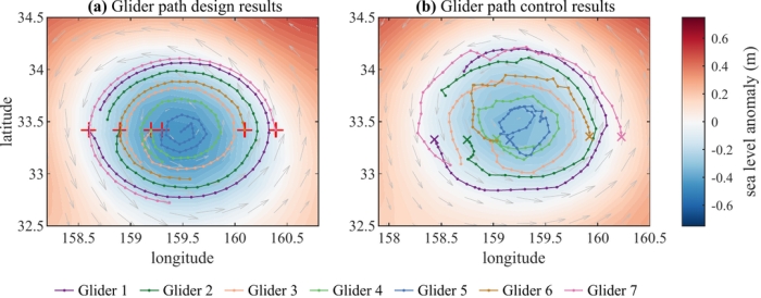
Figure 4. Glider path design and control: (a) designed paths; (b) realized paths.
The work weaves together physical principles, statistical modeling, machine learning and a real at-sea observation task, turning multi-source ocean data that differ in provenance, accuracy and coverage into a credible picture of the three-dimensional current field. It offers not only a new statistical tool for understanding the dynamics inside mesoscale eddies, but also methodological support for ocean environmental monitoring, intelligent ocean observation, and the mission planning and control of autonomous observation platforms.
The first author is Wu Su, who received his PhD in 2026 from the Center for Data Science, Peking University and is now a postdoctoral researcher at Laoshan Laboratory. The corresponding authors are Prof. Song Xi Chen, Wu’s PhD supervisor, and Prof. Yumou Qiu of the School of Mathematical Sciences and Center for Statistical Science, Peking University. Co-authors include He Li, a 2024 PhD student at the School of Mathematical Sciences, Peking University, and Prof. Zhao Jing of Ocean University of China. The work was supported by the National Natural Science Foundation of China and the Fundamental and Interdisciplinary Disciplines Breakthrough Plan of the Ministry of Education, and received technical support from the National Major Science and Technology Infrastructure Project “Earth System Numerical Simulation Facility” (https://cstr.cn/31134.02.EL).
Paper: